CartoVista and ArcGIS Online: A Comprehensive GIS Software Review

CartoVista and Esri’s ArcGIS Online: both of these cutting-edge platforms offer outstanding features and functionalities that empower users to create interactive and captivating maps. In this blog, we’ll do a deep dive into both platforms, analyzing their strengths, and reviewing their current limitations. We’ll explore their mapping and visualization capabilities, learning curve and ease of use, storytelling features, data integration and analysis features, collaboration capabilities, and pricing models. This will help you make a better decision on what’s the best GIS mapping software for your use case. 

Ready to dive in? Let’s go!

Table of Contents

What is ArcGIS Online?

ArcGIS Online is the online component of Esri’s GIS suite designed for GIS specialists. Over the years, Esri has developed GIS tools with numerous extensions. Their SaaS platform ArcGIS Online allows users to upload data and create online interactive maps with their data. As part of Esri’s ecosystem, ArcGIS Online has lots of different features but can be quite complex at times. Although ArcGIS Online was the first to introduce Story Mapping, its steeper learning curve can be somewhat daunting for those who are not familiar with the software.

arcgis home

What is CartoVista ?

cartovista home min

CartoVista is a cloud-based mapping platform designed for creating interactive and engaging Story Maps. Focusing on ease of use, CartoVista democratizes map-making and data analysis, making it accessible to individuals beyond the realm of GIS specialists, data analysts, or developers. The platform combines a seamless user experience with visually stunning aesthetics and a wealth of rich features, including story mapping, live data updates, online editing, and task automation via a powerful REST API. With an affordable entry price, CartoVista empowers users to tell captivating stories with their data and make informed decisions.

Which GIS Mapping Software is the Best For You?

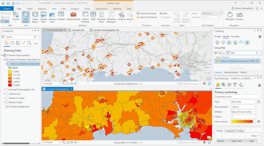
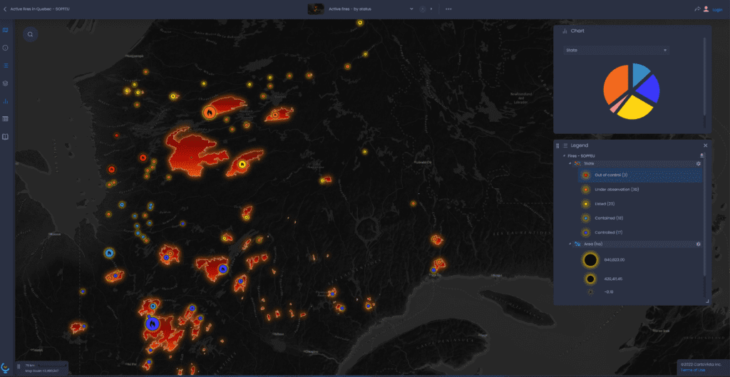
ArcGIS Online benefits from its full integration into the Esri ecosystem and handles large-scale data analysis very well. Whereas, CartoVista allows anyone (not just GIS specialists)  to create engaging Story Maps quickly and easily. 

If you’re an existing Esri user who has the technical skillset to make the most of the Esri platform and does not use story mapping all that often, then ArcGIS Online is probably a good platform for you. 

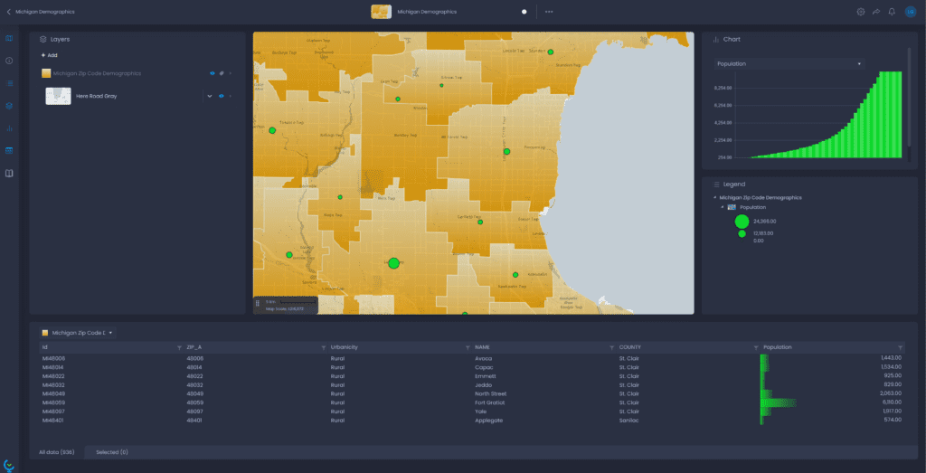
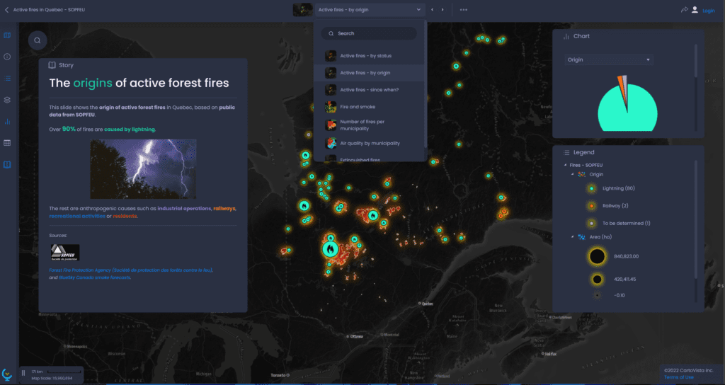
However, if you don’t have an existing Esri license or don’t have advanced coding skills, and are looking to create interactive maps, dashboards, and Story Maps easily, then CartoVista is an excellent choice for you. It also helps that CartoVista supports Esri shapefiles and Web Map Tile Service (WMTS), allowing for smooth data integration and helping scale your projects easily. Moreover, CartoVista offers seamless integration with Esri’s ArcGIS Online by utilizing ArcGIS Feature Services, allowing you to fully leverage the combined capabilities of both platforms. 

This means you don’t have to think of CartoVista as just an ArcGIS alternative. The Feature Services integration lets you unlock advanced mapping functionalities and maximizes each platform’s unique strengths by combining the powers of ArcGIS Online with CartoVista. 

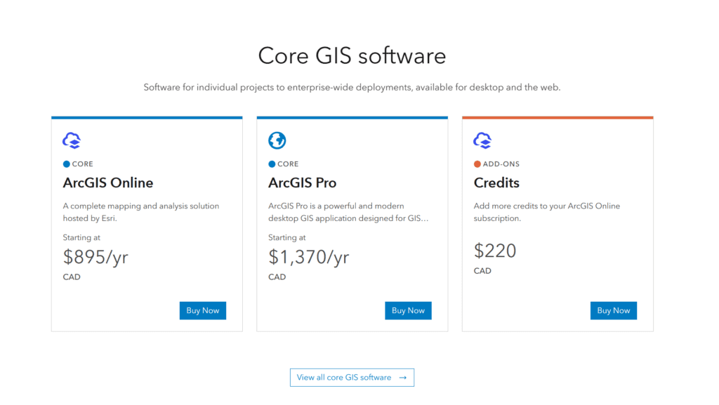
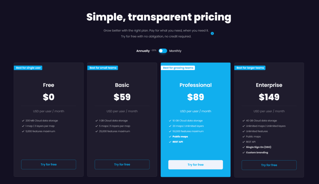
If you don’t have the time to go over the entire detailed analysis, here’s a quick score for both platforms across different categories.

Key ConsiderationsArcGIS OnlineCartoVista
Mapping and visualization icons8 staricons8 staricons8 staricons8 staricons8 staricons8 staricons8 staricons8 staricons8 star
Ease of useicons8 staricons8 staricons8 staricons8 staricons8 staricons8 staricons8 staricons8 star
Storytelling icons8 staricons8 staricons8 staricons8 staricons8 staricons8 staricons8 staricons8 staricons8 star
Data analysisicons8 staricons8 staricons8 staricons8 staricons8 staricons8 staricons8 star
Collaboration and sharing icons8 staricons8 staricons8 staricons8 staricons8 staricons8 staricons8 staricons8 star
Pricing and licensingicons8 staricons8 staricons8 staricons8 staricons8 staricons8 staricons8 staricons8 star
cartovista logo

Start creating your first Story Map for free today!

Head-to-head comparison

Mapping and visualization capabilities

ArcGIS Online: Advanced mapping with adaptable styles and powerful integrations. However, the platform remains complex to use.
CornwallSocialCareLivingAtlasIMD

ArcGIS Online has advanced mapping capabilities and data visualization options. It covers all the basic online mapping features (interactivity, search, table view, layer control, annotations, etc.) and styling options (single or multiple styles, combining multiple data visualization or analysis, etc.). ArcGIS Online is also quite flexible: you can choose the tools and options that you want to enable in your map, so that you can go from a very simple map for a large audience, to an advanced dashboard designed for experts. As part of the wider ecosystem of Esri, it also benefits from connectivity to other GIS tools such as ArcGIS Pro (Esri’s desktop GIS) which allows for complex data analysis and geoprocessing. 

However, we see that the complexity of the platform shows through the maps: online maps produced with ArcGIS Online, a tool made by GIS users for GIS users, tend to be quite complex with lots of different layers the end user has to navigate into. 

CartoVista: Powerful mapping, visualization, and easy storytelling for stunning interactive maps.
map visualization

CartoVista empowers users to effortlessly create stunning interactive maps. The platform offers a diverse range of data representation choices, complemented by an extensive collection of colour palettes and an icon library, enabling you to design captivating maps with ease. 

The inclusion of rendering modes ensures seamless integration of data with the basemap, enhancing the overall visual experience. Using cutting-edge technology, CartoVista showcases features through interactive vectors, delivering an exceptional user experience coupled with seamless data discovery. Its dynamic rollover and data tips capabilities enrich the interaction with the map, enabling users to effortlessly explore and uncover valuable insights. This ensures smooth interactivity, elevating the overall usability and enhancing the way users engage with the data. The integration with the data table view and charts sets CartoVista apart, providing an unparalleled level of interactivity and data visualization.

Notably, CartoVista distinguishes itself from ArcGIS Online with its modern and clean interface, amplifying the impact of your data. The intuitive design and user-friendly interface create an environment where the data truly shines.

Additionally, the CartoVista platform features a dedicated Story component that simplifies the process of adding text and multimedia elements to any map. In a later section, we will explore how CartoVista’s Story map component compares to Esri’s offering, providing you with a comprehensive understanding of their respective capabilities.

Ease of use

ArcGIS Online: A robust GIS tool, but with a complex interface and a steep learning curve.
CornwallSocialCareLivingAtlasIMDCharts 1

ArcGIS Online is primarily tailored for GIS users, making it a compelling option for existing Esri GIS users. Esri users will find its interface familiar, while others may find its complexity and diversity of tools may require some learning. The diverse set of tools and the whole ecosystem may be a bit difficult to understand for new users. While experienced GIS users may get the hang of it after a bit of practice, non-GIS users will definitely be challenged when starting off with ArcGIS Online. 

As for the published maps, the interface can seem a bit austere and not as easy to navigate for non-specialists who do not know about online mapping and only want to get quick and easy information on their territory.

CartoVista: Accessible maps for non-technical users with an intuitive interface, and effortless map creation capabilities.
map interface

CartoVista is guided by the philosophy of making maps accessible to non-technical users. The platform features an intuitive and user-friendly interface specifically designed for ease of use. The simple drag-and-drop functionality for adding new datasets ensures that map creation is a quick and effortless process. Furthermore, CartoVista offers comprehensive in-app tutorials that guide users through the onboarding process, enabling individuals without extensive GIS experience to swiftly grasp the platform’s features and capabilities, minimizing the learning curve. It empowers all users to harness the power of mapping, regardless of their technical background.

Storytelling features and multimedia integration

ArcGIS Online: Template-based story maps, where the maps just highlight the narrative.
arcgis story map

Esri was the first to make Story Maps popular. Focused on narrative storytelling with templates, ArcGIS Story Maps can include images, videos, or other web content. They are structured as a web page where you can scroll down to show new text, images, or maps. The map is not necessarily in the heart of the Story though, and long parts of the Story can be built around images and texts solely. To create a Story Map with ArcGIS, you’ll need to create a map to then convert it or use it into a Story. You will also need to choose a template, customize the layout and the sections to present a coherent story. Esri has also introduced StoryMaps, which differs from ArcGIS StoryMaps: it is not integrated into the ArcGIS ecosystem. It’s directed to non-expert users but unfortunately has somewhat limited mapping capabilities.

CartoVista: Easy-to-use, interactive, and template-free story maps where the map is the heart of the narrative.
story map

CartoVista takes a unique approach to story mapping, offering a more flexible experience. Unlike other platforms, CartoVista eliminates the need for templates and allows you to seamlessly incorporate the story panel into any part of your map. Emphasizing dynamic and interactive components, CartoVista enables you to focus on showcasing the necessary elements while eliminating unnecessary noise. The narrative flow is enhanced through a slide structure, granting you the freedom to design each slide according to your preferences, incorporating the required data and appropriate story content. There is no requirement to convert an existing map into a story; you simply activate the story panel and begin adding content effortlessly. Integrating images and links to external resources into the story panel is also remarkably easy with CartoVista.

Data integration and analysis

ArcGIS Online: Seamless ecosystem integration, powerful data processing, diverse format support.
Screen Shot 2020 01 24 at 3.36.31 PM

One of the strongest arguments in favor of ArcGIS Online is its connectivity to a larger ecosystem, and data integration is a significant part of this. Datasets can be processed in ArcGIS Pro for spatial analysis and modeling, and then opened in ArcGIS Online to share them online. 

ArcGIS supports many formats other than their own formats (Shapefile, File Geodatabases, and Personal Geodatabases), notably KML, GeoJSON, and Excel data tables. They also offer a library of data sets and tools for data exploration.

CartoVista: Effortless data integration with diverse formats, geocoding, web services, enhanced automation and real-time updates.
live data

CartoVista excels in delivering robust data integration capabilities, empowering users to seamlessly connect and visualize diverse data sources. With CartoVista, you have the flexibility to integrate various file formats, including Shapefiles, Mapinfo files, KML, GeoJSON, and PIX files. For non-GIS users, the platform offers the convenience of importing and geocoding Excel or CSV files containing coordinates or addresses. Additionally, CartoVista allows for seamless connectivity to web services, including ArcGIS Feature service, enabling you to harness the power of Esri’s advanced ecosystem within the CartoVista user experience.

In addition to its array of features, the CartoVista REST API further enhances data integration and automation capabilities. CartoVista goes the extra mile by simplifying the process for users to track and stay informed about their data updates. Through live notifications directly within the map interface, users receive real-time updates whenever features or layers are modified. This seamless integration of live notifications ensures that users always have the most up-to-date information at their fingertips.

Collaboration and sharing

ArcGIS Online: Secure and accessible mapping for enterprises.
esri share

ArcGIS Online is designed for large enterprises and offers robust security features. You can decide who has access to which map and dataset in a secure manner. There are sharing options to make maps accessible to specific groups or the public. When made public, maps can be integrated into websites or social media posts. It also allows multiple users to contribute to an Esri story map.

CartoVista: Best-in-class data security, collaboration capabilities, and live update features with enhanced interactions.
live data cue

Data safety and security lie at the heart of CartoVista’s engineering philosophy. The platform ensures secure storage of data in the cloud, with access strictly controlled by unique login credentials. To provide the utmost flexibility, permissions for maps and data are independent, allowing users to precisely determine which users have access to specific datasets and maps. CartoVista also empowers users to make maps public and seamlessly integrate them into websites and applications, facilitating broader accessibility and sharing.

Collaboration is seamless within CartoVista, enabling teams to work together effortlessly on map projects and data updates. When visualizing or editing a map, you have the option to activate Live mode, which enables real-time visibility of edits made by your co-workers. This dynamic feature enhances teamwork, fostering efficient collaboration and ensuring that everyone stays in sync with the latest changes.

Pricing & Licensing

ArcGIS Online: Complex pricing with the use of credits and separate licenses for each product.
esri pricing

ArcGIS Online provides various licenses tailored to different user types, distinguishing between map creators and administrators versus map viewers. Each license includes a specific allocation of credits, which are utilized for activities such as data storage and map transactions (e.g. geocoding, spatial analysis, etc.). Consequently, pricing may vary depending on the scale and usage requirements, making it challenging to obtain an accurate cost estimation and anticipate expenses. It’s important to note that accessing additional Esri products and services requires separate licensing agreements, further contributing to the complexity of pricing considerations.

CartoVista: Flexible and affordable pricing, with a free 14-day trial.
cartovista pricing

CartoVista offers transparent pricing plans based on the number of users, providing organizations with the flexibility to select a plan that perfectly matches their specific needs. The pricing structure consists of three plans: Basic, Professional, and Enterprise. 

CartoVista’s pricing plans are designed to be cost-effective, catering to the requirements of small, medium-sized, and large organizations alike. For instance, the Basic plan starts at an affordable monthly price of just US$59 per user, making it an ideal choice for personal use or small projects.

Moreover, CartoVista provides a free 14-day trial, allowing you to explore the platform’s capabilities firsthand. This trial period lets you assess the value and suitability of CartoVista for your organization, before making any commitment.

Verdict

CartoVista is a powerful integration for existing ArcGIS Online users (and an excellent stand-alone solution, too)

Both CartoVista and Esri ArcGIS Online provide robust mapping solutions, each with its own distinctive features and capabilities. CartoVista stands out for its user-friendly and modern interface, offering advanced visualization options and facilitating seamless collaboration. The great news is that CartoVista seamlessly integrates with Esri's ArcGIS Online through ArcGIS Feature Services, enabling you to harness the combined power of both platforms. By leveraging this integration, you can unlock enhanced mapping capabilities and combine the strengths of both platforms to take your projects to the next level!

cartovista logo

Start creating your first Story Map for free today!