The CartoVista team is pleased to announce the official release of CartoVista Cloud version 8.3, which was successfully deployed on August 3rd, 2023. We’re excited to share that version 8.4 is right around the corner, with a scheduled release date of August 18, 2023.
Our diligent software engineering team remains committed to continuous improvement, working tirelessly to enhance our platform on a monthly basis. These efforts are aimed at empowering our customers to create more engaging and interactive experiences for their users.
This latest iteration of CartoVista Cloud brings a range of enhancements, particularly focusing on optimizing user experiences when embedding public CartoVista maps on external websites. We’re dedicated to refining the usability and functionality of our platform to better serve our users’ needs.
Stay connected with us for more updates and innovations from CartoVista. We’re dedicated to evolving the landscape of online experiences, one version at a time.
What's New?
Collapsible Top Bar and Left Bar
Navigate with ease and maximize your screen’s potential. We’re excited to introduce a practical addition to our interface. Now, you can simply collapse the top and left bars, instantly creating more space to focus on your map and stories. Enjoy a clutter-free view that puts your content front and center. It’s a functional enhancement designed with your convenience in mind.
Collapsed top bar and left bar map
Interface Map Settings
Experience newfound control over your map’s setup. Our latest update introduces an option within map configuration that lets you specify which panels are accessible to your users – whether it’s layers, info, legend, chart, story, and more. This level of customization ensures your map aligns precisely with your intentions.
Furthermore, you can now curate the items visible in the top bar – from the title and slide controls to the share button, notifications, and user menu. This enhancement empowers map creators with flexibility, allowing you to streamline the interface according to your preferences. It’s about optimizing functionality to fit your users needs.
Interface map settings
Enhanced Info Tool User Experience
In this latest iteration of CartoVista, we’ve improved the info tool within your map. This tool is well-known for its capacity to offer comprehensive information when clicking on map features.
Now, you’re empowered with a new choice: configuring the info tool to appear as a feature popup window directly within the map itself. This shift from the default panel display offers distinct advantages.
Info Tool Feature Popup
The new feature’s info popup seamlessly adapts as the end user navigates the map. It cleverly maintains its connection to the clicked feature, ensuring precise alignment regardless of map movement.
Especially beneficial for maps designed for public use, this update ensures that the info popup remains seamlessly attached to the precise location clicked on the map. For instance, urban planners presenting city landmarks or heritage sites sharing historical insights can benefit from this streamlined approach.
Accessing this feature is straightforward. Map creators can opt for this configuration adjustment within the advanced map settings under the info tool section. This nuanced customization option enhances both accuracy and user experience, representing the progression of interactive map design.
Info Tool Settings
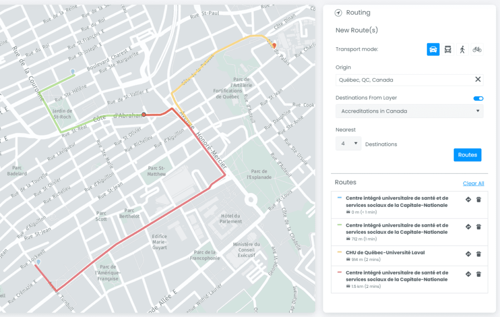
Enhanced Route Technology
Find the best routes between Point A and Point B. Our latest route functionality allows users to select any two locations and charts out the most optimal route. With direct API integration with HERE Maps, CartoVista’s route functionality analyzes multiple factors, like road networks, traffic conditions, and even potential obstacles, to chart out the most optimal route.
Your route comes with complete step-by-step directions and estimated travel time. Beyond just showing directions, it also accommodates various preferences, allowing users to choose between different modes of travel, such as using cars, public transportation, cycling, or walking.
Route from Point A to Point B
This technology has multiple applications. Municipalities can identify traffic congestion and identify inefficiencies in public transport routes, allowing for better urban management. Businesses can use it to discover improvements in supply chain management, optimize delivery routes and schedules, and reduce operational costs. Furthermore, by integrating it with other data points, users have the flexibility to customize their routes based on specific criteria, making it a highly flexible and powerful addition to your tool kit.
Integrating your routing options to points on layers makes this functionality highly customizable.
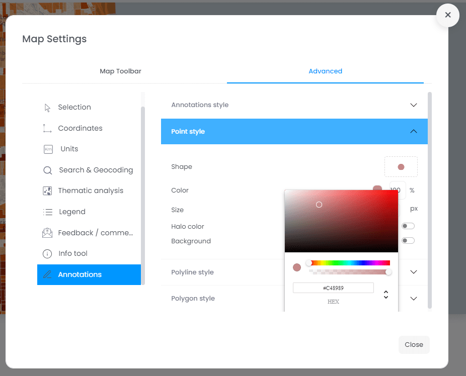
Annotations default styles
CartoVista’s annotation tools offer practical ways for end users to communication with their maps. They can effortlessly add drawing elements like pins, polygons, or circles to emphasize specific areas of interest.
In our latest version 8 update, we’re putting more control in the hands of map creators. Now, you can customize default styles for annotation features. This means you can set preferences for annotation font size, color, polygon fill, stroke, and more. It’s about tailoring the tools to suit your needs and maintaining a consistent look.
Default Annotation Styles
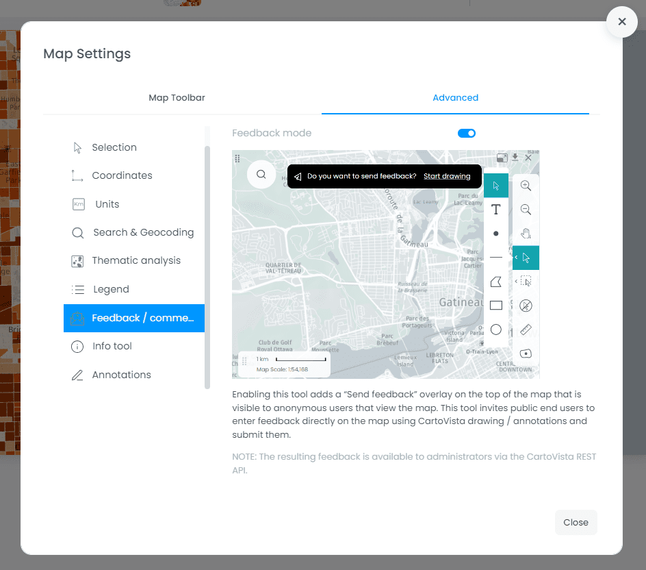
Feedback / Comments Tools
In response to the growing need for public input, many of our clients have turned to interactive maps to gather feedback on various initiatives. A concrete example is a city’s effort to involve citizens and the general public in discussions about new infrastructure locations.
To cater to this demand, we’ve developed a new Feedback tool. This tool is designed to enable anonymous users to utilize CartoVista’s drawing tools, providing a simple way to submit feedback directly on the map. When activated, this tool adds a “Send feedback” overlay to the map interface, visible exclusively to anonymous users. This overlay encourages users to contribute feedback using drawing and annotation features, facilitating a more hands-on engagement approach.
The outcome of these interactions is far from ephemeral. The feedback submitted by users accumulates into a valuable resource, accessible to administrators through the CartoVista REST API. This creates an organized repository of insights, fostering informed decision-making processes.
In essence, CartoVista’s Feedback tool transforms public consultations into a streamlined experience, where user-generated input becomes an integral part of the decision-making landscape.
Feedback / Comments Tools for the public
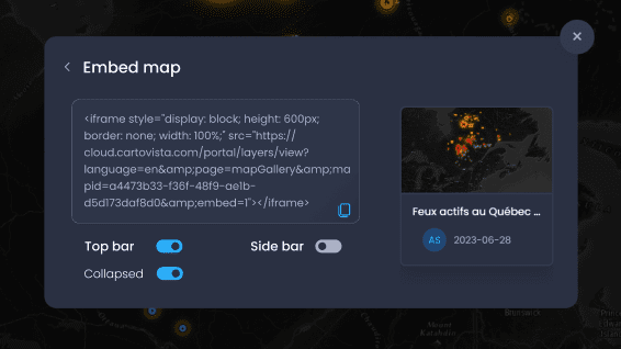
Sharing and embedding a map on a public web site
Many of our clients find value in the simplicity of crafting maps using the CartoVista platform, especially when they plan to share these maps publicly. Version 8.4 introduces tools that make embedding maps on your own website even easier.
This update focuses on improving the sharing process. The updated share dialog now includes an “Embed map” option. When selected, a dialog box will provide you with the necessary code to seamlessly integrate the map into your website using an iframe. Additionally, you have the flexibility to decide whether to display or hide the top bar, and whether it should be collapsed by default.
This enhancement simplifies the integration of CartoVista maps onto external websites, providing more control over the display and interaction aspects of the embedded maps.
Enhanced Sharing – Embed Map
Single Sign On (SSO) and OpenID Connect (OIDC) Support
OpenID Connect (OIDC) offers a robust and secure solution for implementing Single Sign-On (SSO) across applications and services. SSO allows users to access multiple systems with a single set of credentials, streamlining the authentication process and enhancing user experience.
Through OIDC, your CartoVista workspace can be configured to connect with Windows Azure Active Directory. When enabled, enterprise end users can simply log-in in via their enterprise SSO (corporate account) using a button. It is also possible to login with an alternate account.
In summary, OpenID Connect in version 8 offers a robust and standardized approach to Single Sign-On, enhancing user convenience, security, and administrative efficiency. It simplifies authentication and access management, making it a valuable tool for enterprises looking to provide seamless yet secure access to their services.
Windows Azure AD – Single Sign On (SSO)
Other enhancements
This new release features many other enhancements such as new login pages, Search Engine Optimization (SEO) improvements when creating public maps and several other bug fixes.
CartoVista
The CartoVista platform unlocks the power of web mapping in the cloud:
• Design intuitive data visualizations and sophisticated presentations that puts YOUR data on a map.
• Create meaningful stories that will impress your stakeholders and make better business decisions.