Layer Control

The Layer Control panel is used to manage the visibility, labelling and opacity of each map layer.
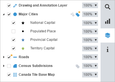
The following describes the various options available in the layer control:

|
Display the layer style(s). |

|
Hide the layer style(s). |

|
Display a layer's map features. |

|
Hide a layer's map features. Note that you can also manage the visibility of each style in a map layer independently. |

|
The star indicates that the layer is hidden due to visibility range. Change the map scale using the zoom in or out to display the layer. |

|
The features of this layer are added on the map using the Drawing and Annotation Toolbar. |

|
The map features of this layer are points. |

|
The map features of this layer are polylines. |

|
The map features of this layer are polygons. |

|
This layer is a tile base map. When there are multiple tile base maps available, select which to use from a drop-down list. |

|
Display the points of this layer as data clusters. See topic on Clustering for more information. |

|
Display the points of this layer as regular points. |

|
The star indicates that the clustering is forced due to visibility range. Change the map scale using the zoom in or out to display the points of this layer as regular points. |

|
|

|
Hide the labels. |

|
The star indicates that the labels are hidden due to visibility range. Change the map scale using the zoom in or out to display the labels. |

|
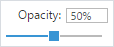
Insert the percentage directly in the text box or drag the slider to the desired level of opacity. Note that it is also possible to manage the opacity of each style from the same layer.
|